Immer samstags gibt es hier einen Sammelpost mit allem, was es nicht zu einem eigenen Artikel gebracht hat. Das ist mal mehr, mal weniger. Mal gucken, wie’s klappt.
Misplaced: New York
Eleven New York City landmarks have been misplaced, their current location unknown. Photographs of unclear origin appear to show them scattered across the globe – on sand dunes, mud flats, “lunar” plains, and rocky beaches. Nobody knows exactly what happened or why. Did they act of their own volition? Was there foulplay involved? What does it all mean? Stories trickle in from the future, from architects, online reviewers, and the buildings themselves, but these only add to the confusion. Your curiosity and help is much appreciated.
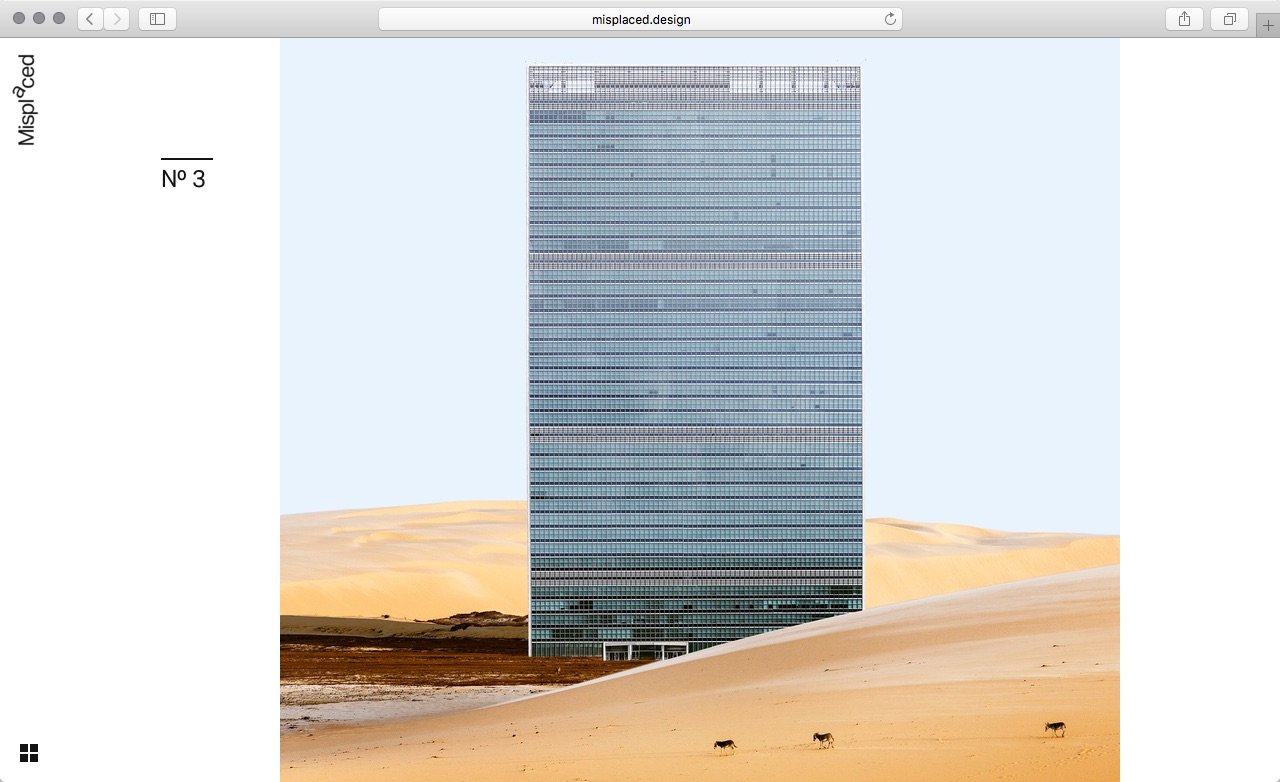
(via swiss-miss.com)
NASA’s 4K View of April 17 Solar Flare
On April 17, 2016, an active region on the sun’s right side released a mid-level solar flare, captured here by NASA’s Solar Dynamics Observatory. This solar flare caused moderate radio blackouts, according to NOAA’s Space Weather Prediction Center. Scientists study active regions – which are areas of intense magnetism – to better understand why they sometimes erupt with such flares. This video was captured in several wavelengths of extreme ultraviolet light, a type of light that is typically invisible to our eyes, but is color-coded in SDO images for easy viewing.
Stunning Aurora Borealis from Space in Ultra-High Definition (4K)
NASA Television’s newest offering, NASA TV UHD, brings ultra-high definition video to a new level with the kind of imagery only the world’s leader in space exploration could provide.
Harmonic produced this show exclusively for NASA TV UHD, using time-lapses shot from the International Space Station, showing both the Aurora Borealis and Aurora Australis phenomena that occur when electrically charged electrons and protons in the Earth’s magnetic field collide with neutral atoms in the upper atmosphere.
(via Blogrebellen)
The Great San Francisco Earthquake: Photographs From 110 Years Ago
110 years ago next week, on April 18, 1906, a magnitude 7.8 earthquake centered near the city of San Francisco struck at 5:15 AM. The intense shaking toppled hundreds of buildings, but the resulting out-of-control fires were even more destructive. Broken water mains and limited firefighting capabilities allowed city-wide fires to burn for several days. Nearly 500 city blocks were leveled, with more than 25,000 buildings destroyed. At the time, the city was home to more than 400,000 residents—after the disaster, 250,000 were left homeless. The exact death toll is undetermined, but most estimates place the number of deaths caused by the earthquake and fire at more than 3,000.

Stopping All Stations – The Pyongyang Metro
During my visit to North Korea, I was part of the first ever group of foreigners given access to all stations across both lines of the Pyongyang Metro. This may sound mundane, but the previously restricted Pyongyang Metro is surely one of the most mysterious, yet beautiful transit systems on earth, each station uniquely themed in ultra-nationalism, parading North Korea’s revolutionary goals and achievements to impressionable commuters. In many ways, it’s a small museum, most of which formerly hidden from outside eyes and subsequently shrouded in conspiracy theories. Sensationalism aside, here’s my journey in over sixty photos of the beating heart of Pyongyang, the Pyongyang Metro.
Mit der U-Bahn durch Nordkoreas Hauptstadt? Da wär ich sowas von dabei! Aber erstmal Fotos…